
The ecoPi series are a collection of modular devices we developed and built based on the implementation of an economical Raspberry Pi single-board computer (RPi, Raspberry Pi Foundation).
What is the ecoPi:Bleep?
The ecoPi:Bleep is a stand-alone bat telemetry unit developed on the basis of the open-source project Radio-Trackig.eu.
All native bat species are specially and strictly protected in Germany under the European Habitats Directive (Annex IV). This is why bats are not only a regular part of monitoring programs, but also a central component of many planning appraisals (examination of prohibitions according to BNatSchG § 44 paragraph 1). Telemetry is an essential method for investigating the spatial behavior and habitat-use of bats.
Classical telemetry methods for assessing spatial behavior and habitat-use, based on the principle of triangulation, are usually associated with high personnel costs and thus often only few individual animals can be studied. Additionally, classical telemetry does not have the spatial accuracy needed to draw conclusions about the flight routes of tracked animals, as bats on transfer flights can only very rarely be located synchronously from two positions at the same time.
Our goal was therefore to optimize the recording of radio tagged bats and generate the most reliable data possible, (particularly regarding flight routes) at a relatively low cost and with minimal personnel requirements. For this reason, we developed the ecoPi:Bleep.
How does the ecoPi:Bleep work?
Bats fitted with radio transmitters are automatically detected by a small receiver station - the ecoPi:Bleep - when the animals fly past the devices within their detection range (ca. 50 m). The detection range of the ecoPi:Bleep depends on the local conditions (vegetation density, landscape topography, etc.) and can be significantly influenced by the choice of the installation point and the choice of antenna.
ecoPi:Bleep devices are distributed throughout the study area. The number of devices installed will depend on the size of the study area and the research question to be investigated. Site-specific flight paths can only be determined in this way, using a sufficient number of devices to ensure good spatial coverage of the whole study area. The number of bats that can be surveyed within this area is only restricted by the frequency of the transmitters and the possible combinations of frequencies and pulse patterns produced by transmitters. Each transmitter must be distinguishable from other transmitters for evaluation of the data.
The ecoPi:Bleep runs using the open-source software from the project Radio-Tracking.eu. The software makes it possible to process and store the received radio signals in a defined frequency range. Via remote access to the devices it is possible to adjust the operational and detection settings and to download stored data. Remote access is available via WLAN in close proximity to the devices whilst they are running.
How is the ecoPi:Bleep constructed?
The ecoPi:Bleep consists of a robust plastic box with the receiving antenna installed on the bottom outside. Inside the box are the various technical components, including the heart of the device - the RPi single-board computer, on which the recording software is installed.
The devices are equipped with a solar panel and a battery module, as such they can operate self-sufficiently.
All components of the ecoPi:Bleep are modular and can therefore be transported in a space-saving manner.
-
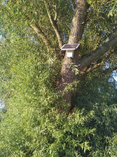
An ecoPi:Bleep installed in the study area.
© OekoFor GbR -
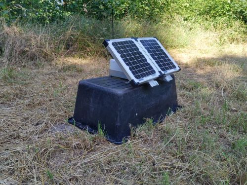
Depending on the landscape structure, ecoPi:Bleep can also be installed close to the ground.
© OekoFor GbR -
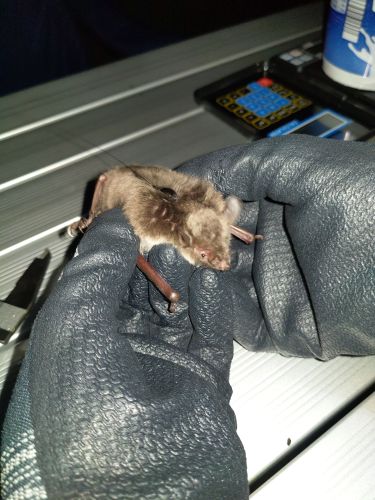
A Pond Bat (Myotis dasycneme) fitted with a radio transmitter.
© OekoFor GbR -
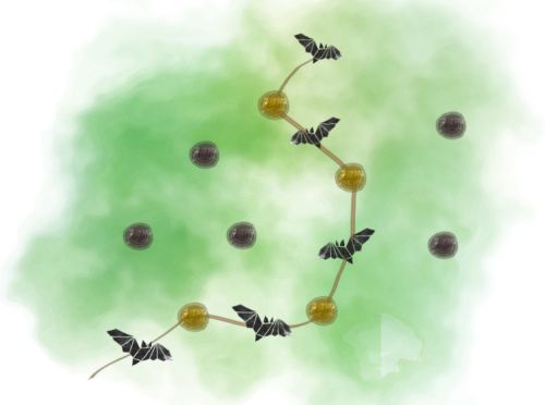
A schematic diagram showing the operating principle of the ecoPi:Bleep.
The flight path of a tagged bat can be reconstructed based on the ecoPi:Bleep devices it passed.
© OekoFor GbR
Typical applications
The ecoPi:Bleep is particularly well suited for use in projects assessing the habitat-use of bats in a specific study area. Surveys for planning reports and monitoring programs can be carried out with the ecoPi:Bleep, the ecoPi:Bleep can also supplement such surveys very well with additional high resolution spatial data on individual bat movements.
The ecoPi:Bleep has already been successfully used for surveys in the course of a road construction assessment. Based on the results it was possible to identify concrete focal areas of possible road crossing by bats. Protective measures for the animals can thus be planned and implemented in a site-specific tailored manner.